 |
By David Kier
The desert valley southwest from San Felipe offers several driving and hiking adventures. With many dirt roads, palm filled canyons, waterfalls, and hot springs, the attraction is undoubtable. As with most Baja journeys, one should have a four-wheel drive or off-road vehicle to reach most of these locations, plus a good pair of hiking boots. There are no stores, no gasoline stations, and almost no people once you leave Highway 5.
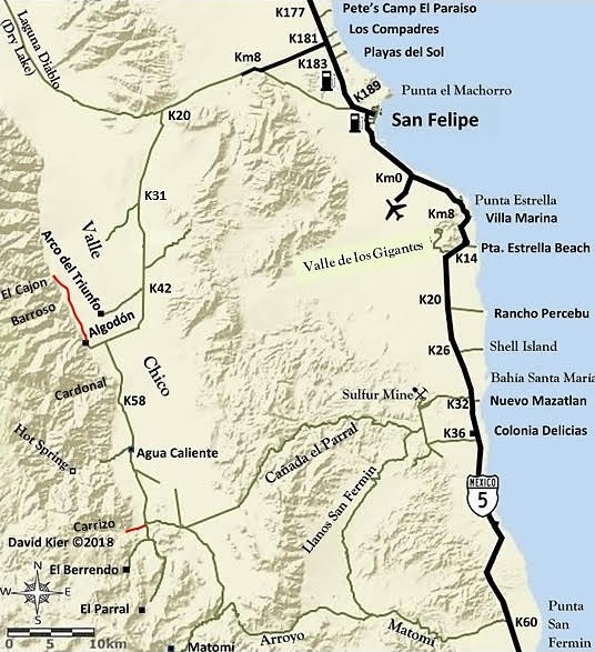
Begin the trip on Highway 5 at Km. 181, just north of San Felipe. The road heading west, signed for Colonia Morelia, is paved for 10 kilometers (6.2 miles). From that point the graded dirt road over the next 34 miles is generally a fast, easy drive to the center of Valle Chico. Any travel beyond the graded road should only be in an off-highway vehicle with good tires.
Along the eastern slope of the Sierra San Pedro Mártir mountains are dozens of canyons worthy of exploring. Many have petroglyphs, running water, and palms. These canyons that flow into Valle Chico, south of Diablo Mountain include:
El Cajón: A large canyon system with running water to the desert floor. Petroglyphs are under a large rock in center of canyon entrance. A trail here was once used by Indians and missionaries going between San Felipe and the forest above. A walk up the canyon floor from the entrance fence quickly changes from harsh desert to tree-lined stream in the mountain condition.
Barroso: A wading pool, waterfalls, and petroglyphs are found if this less-known canyon can be entered. A cattle fence, and plant growth, might block passage.
Cardonal: A deep, long canyon with fan palms and an Indian trail to the mountain top..
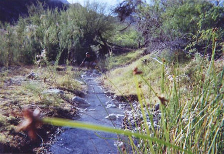
Agua Caliente: Another large canyon named for the hot springs located 3.8 miles up from the canyon entrance, along the righthand side of the canyon. The quantity of hot water is such that a steaming-hot stream runs for several hundred feet. A cool mountain stream runs down the middle of the canyon providing for one of nature’s unique places with hot and cold running water. Flash floods prevent developing the site and the road may not be passable a mile or more from the springs.
Carrizo: A palm filled canyon also with an Indian trail to the mountain top. It is possible the Jesuit explorer Wenceslaus Linck reached Valle Chico this way before arriving at Agua Caliente hot springs on March 22, 1766.
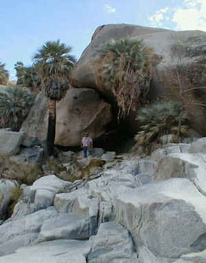
Berrendo: A beautiful, blue palm filled canyon is just beyond the white sand arroyo parking spot. Blue palms also grow high up on the canyon slopes. A one-mile hike up this canyon will be a rewarding one with a look at huge boulder-created exotic grotto.

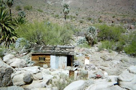
Parral: An old ranch house is located among many long rock walls about a mile beyond where the road is washed out near a corral. A running stream, as in the other canyons, provides tranquility even in the harshest climate of summer.
Another canyon, also called Parral, is a pass going east between Valle Chico and the sulfur mine area on the old Puertecitos road. To avoid confusion, this Parral canyon is sometimes called ‘Azufre Wash’ or ‘Crazy Horse Canyon’.
Matomí: The southernmost canyon of the San Pedro Mártir range and the southern edge of Valle Chico. The old ranch house is 5 miles upstream from where the Valle Chico road drops into this canyon. A short walk behind the ranch house, down to the arroyo, is the famous Matomí waterfall. Not that it is very big, but it runs year-round and fills a large, deep pool. Blue palms continue up the canyon as far as you care to hike.
Road Log in miles:
0.0 Highway 5 at Km. 181
6.2 (K10) End of pavement
12.8 (K20+) Fork. Go left (south). Ahead (west) goes to Diablo Dry Lake.
19.5 (K31+) Road west to Rancho El Cajon.
26.0 (K42) Road west to Arco del Triunfo (rehab center).
31.5 Junction with road south. Ahead (west) is Rancho Algodón (1.3 mi). North from Algodón is the entrance to canyons Barroso (4.3 mi) and El Cajon (6.1 mi). Going south…
39.6 Agua Caliente Fork (ranch at road junction, and an abandoned farm village). Take the west road 2 miles to canyon entrance. Hot springs are 3.8 miles inside canyon. Petroglyphs are high up the cliff on the south side from the gate just inside the canyon.
45.0 Fork. Matomí road turns left (east). Ahead (south) is the Carrizo Canyon road (0.2 mi), the Berrendo Canyon road (1.5 mi), and with a mile hike, Rancho El Parral (9 mi).
48.1 Azufre Wash (Cañada el Parral) road east to the Sulfur Mine (25 mi) and Highway 5 (29 mi) near Km. 32.
56.1 Arroyo Matomí. Highway 5 is 27 miles to the east but large rocks may block passage to most vehicles in 2.8 miles. Rancho Matomí and the waterfall fed pool is 5 miles to the west.
61.1 Rancho Matomí.
About David
David Kier is a veteran Baja traveler, author of 'Baja California - Land Of Missions' and co-author of 'The Old Missions of Baja and Alta California 1697-1834'. Visit the Old Missions website.

Easiest method of getting Mexican auto insurance. Best rate we found and was setup in no time.

Easy, dependable, and fast online insurance. Lots of travel info on website.

Easy to get an insurance policy. Felt safter having it even though we didn't need it. Follow the...