 |
By David Kier
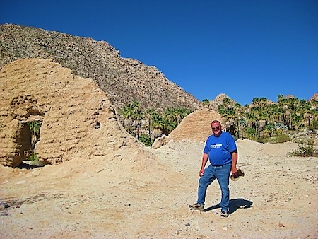
Santa María de los Angeles was the last mission established by the Jesuits, located in a desert-oasis canyon, midway between San Luis Gonzaga Bay and today’s town of Cataviña. Adobe walls, built by the Franciscans in 1768, and stone corrals, remain. For over one hundred years, this mission has been the subject of adventure stories, and for good reason; the location is almost impossible to reach! It was not until the 1960s that a vehicle could even drive to Santa María.
Fred Hampe, a foreman at Rancho Santa Ynez, took it upon himself to blast and bulldoze a road from there to Mission Santa María, and beyond. The goal was a more direct road to Punta Final, on Gonzaga Bay, which the ranch also owned. This would cut about fifty miles and save many hours of rough driving. This was in the days before Highway One existed.
Hampe’s progress was halted about two miles past the mission when he reached the edge of a deep canyon. The arrival of a paved highway through nearby Cataviña likely helped to decide to not build beyond the canyon’s edge? Howard Gulick (author of the Lower California Guidebook) writes that in 1961, construction of the road had reached a point 12.1 miles from Santa Ynez, just over two miles from the mission. Photos, from Perry Mason author (and huge Baja fan), Erle Stanley Gardner, shows the new road was briefly passable in VWs. Jim Hunter’s 1977 guidebook, Offbeat Baja, was the first to detail the full drive as a 14.5-mile-long road, most people should avoid! The term “Mission Impossible” has also been applied to Santa María by many writers.
The recommendation for driving this road is having four-wheel-drive, plus a locking differential or traction control. Either of these are useful to better climb the steep grades with loose rocks. Good off road tires and over nine inches of ground clearance is also necessary. Still, expect rock damage! Do not travel without a buddy-vehicle. This road is for those seeking adventure and is no joke.
My first time over the notorious road was in 1999, using a quad, with a friend on a motorcycle. We went in and back out in one day from Santa Ynez. This mission location (and the road) so enchanted me that I had to return! The next trip was in 2003 with my daughter in my 2001 Toyota Tacoma 4x4. Two other rigs went in with me: a Jeep, and another Toyota truck. We spent two days at the mission and hiked to the end of Fred Hampe’s bulldozed road where we saw petroglyphs and looked down the deep canyon.
The third trip was in 2007 with my fiancé, in my 2005 Tacoma. We traveled with another couple in their new Land Rover LR3. We camped two nights a mile drive from the mission along the palm-lined sandy arroyo with a large oasis pool. A family of bighorn sheep paid us a visit in the morning! We later hiked to see the Camino Real mission trail. The fourth trip was in 2010 with my wife in our new 2010 Off Road Tacoma. Five other vehicles joined us (two more Tacomas, a 4Runner, a Dodge Dakota, and a custom-made 4x4 van/motorhome with front and rear locking differentials). This was a most-amazing trip, and the motorhome did great despite our opinion in the beginning he would not make it. One of the other Tacomas actually had to be towed out of the mission valley, after its differential failed. The water in the bog, near the mission, was also two feet deep!
In 2022, four vehicles (two Toyota Tacomas, a Jeep Wrangler, and a Jeep Grand Cherokee) and eight people made the journey to Baja’s most difficult-to-drive-to mission. I was invited by my amigo Tom to ride in his Tacoma, making this my fifth trip to Santa María. We began with a drive from San Diego to El Rosario, that included a stop at the grandpas’ home to drop off some donations: The Grandpas of San Jacinto. Dinner at Mama Espinoza’s and a sound sleep at the Baja Cactus Motel ended the first day in Baja.
Day Two began with breakfast at Mama Espinoza’s, and the 77-mile drive to Rancho Santa Ynez. This is where the adventure really begins! We regrouped at the Santa Ynez camping area, checked our rigs, and departed from civilization wondering what might happen in the following hours.
Since my previous trip to Santa María, 12 years earlier, a new route had become popular. It stays longer in the arroyo, bypassing the first deep gully crossing on the original, higher road. We missed taking that fork and ended up on the old road, built over 60 years ago by Fred Hampe. It was tough, now rarely used, but we all made it through and eventually saw where the new, arroyo road returned to the old road. On the return, we would not miss the opportunity to use the newer arroyo route going back.
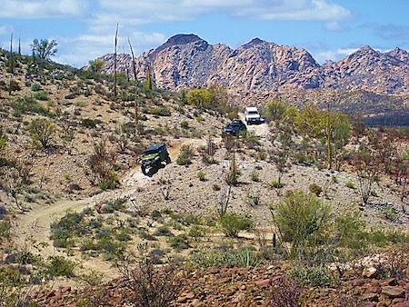
About eight miles from Santa Ynez was the first pair of incidents to our travel train. The Jeep Wrangler developed a metallic knocking in the rear. The shock mount nut came off allowing the rattle. A spare Toyota lug nut made a temporary fix. While that was going on, we discovered that the front tire on the Tacoma I was in had gone flat! Tom used one of those spare tires in-a-can, to make a temporary fix. Ten miles from Santa Ynez is the peninsular divide or highest point on the road with its grand view of the Sea of Cortez and Punta Final. This is 4.5 miles from the mission. From there, it is almost all downhill to the mission valley! This is the really difficult part of the road as you wonder how you will be able to climb back up these steep down-grades.
Tom’s temporary tire repair was very temporary, and the tire split open at the bottom of the first gully crossing past the divide. The youngest guys of our group, Ed and Phil were an immense help in changing the tire for us. The road was much harder to drive than in 2010, with grades that seemed steeper with bigger washouts to negotiate. I got out a few times to help spot tire placement as the hood of the truck blocks visibility when the road drops away so steeply. We reached the ‘Widowmaker’ which is the rocky grade down to the first oasis. It was the hardest part of the drive in years past and was where my friend and I were both dumped off of our rides in 1999, leaving our blood on the rocks. That was when I gave it the name, ‘Widowmaker.’
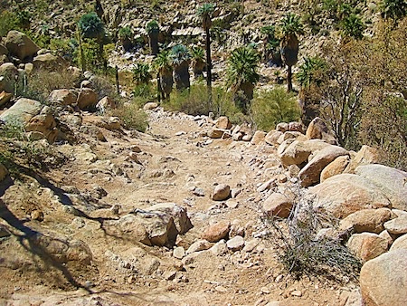
After the Widowmaker, the road goes into an oasis which was underwater in 2010 and 2003. We called it ‘the bog.’ This year, as well as in 1999 and 2007, it was dry, making one less of the past hazards of the drive. Between the bog and the mission are deep gullies and is where you are glad to have big tires and extra ground clearance.
The mission ruins were once again magnificent to see. We arrived just as the sun was going behind the granite peaks, six hours after leaving Santa Ynez! I took photos with the light that was available. Once all the vehicles arrived, we discussed camping options. Phil, who was riding with Ed in the Grand Cherokee, jogged down to the palms just east of the mission and found that to be the ideal camping location. It already had a large fire pit, and the breeze was less, to help with the cooking. Phil is a chef and owns a French restaurant in San Luis Obispo. We ate well on this trip!
Fun stories were told around the campfire by Rudy, who drove the other Tacoma with his friend Ken. Two ladies were in the Wrangler, Debbie the driver, and Miriam, who is Ed’s wife. Miriam had fun jokes to tell us, as well. Because what happens in Mission Santa María stays in Mission Santa María, I cannot share those jokes!
The next day was beautiful and as soon as the sun rose, I was taking photos of the mission. We packed up and after group photos, headed back to Santa Ynez. The Grand Cherokee did not have a locking differential or traction control. That prevented it from climbing one of the grades. Rudy and Ken, in a Tacoma, were behind Ed and Phil. They helped build a ramp with rocks for the Jeep to get out. We stopped for lunch where the new road and old road join and reached Santa Ynez after just three hours on the 14.5 mile road.
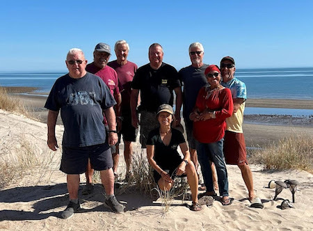
In nearby Cataviña, we bought some gas from the vendor and aired up the tires for the highway. We would take the new paved Highway 5 from Laguna Chapala north, with a visit to the new Coco’s Corner. Coco was incredibly happy and getting around in an electric wheelchair. The drive to the South San Felipe Campos, where Rudy has a beach house, was easy and uneventful. Before heading home, the next morning, we had one final group photo. An excellent group trip with Baja amigos is in the books!
See all the 2022 trip photos here; the 2010 trip; and the 2007 Trip.
*Please note that the roads featured in this article are not conventional roads, paved and dirt roads designed for the normal transit of vehicles, and our insurance coverage would not apply.
About David
David Kier is a veteran Baja traveler, author of 'Baja California - Land Of Missions' and co-author of 'Old Missions of the Californias'. Visit the Old Missions website.


