|
By David Kier
The Admiral Isidoro de Atondo y Antillon and Padre Eusebio Francisco Kino overland expedition was the first crossing of the peninsula by Europeans from the Gulf of California to the Pacific Ocean. This was an important quest for the Spanish as they sought a harbor for the Manila Galleon to obtain fresh water and food during the long trip to Acapulco from Asia. Also important for Padre Kino, who saw the beautiful blue abalone shells on the Pacific coast. Years later, Kino saw them again with the Indians in today’s Arizona. This was proof to Padre Kino that California was not an island! Abalone shells do not exist in the Gulf of California.
Joining Atondo and Kino were twenty-nine soldiers, a surgeon, a muleteer, a slave, and nine Christian Indians from the Mainland. The animals used included thirty-seven horses and forty-four mules. An unspecified number of unbaptized-Native Californians were also along to function as guides. This was indeed a major undertaking for the young colony of San Bruno, founded on October 6, 1683. See San Bruno: The Oldest Spanish Ruins in All of California
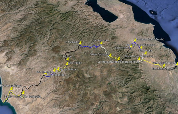
Admiral Atondo kept a daily diary giving his estimated travel distances in leagues along with the Native place names. The Spanish also gave names to these places they saw. A league was the distance traveled in one hour, which can vary between two and three miles depending on the terrain. Atondo’s leagues were usually no more than two miles and often less. The terrain was rugged and required a great deal of trail building over the mountains and in the riverbeds.
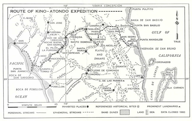
The diary was translated by W. Michael Mathes in a 1969 book, ‘First from the Gulf to the Pacific.’ The book included a 1960 map showing the route, drawn by Ronald L. Ives. Assumptions were made by both Mathes and Ives to complete the story, mostly due to lack of better maps, location details, and satellite imagery. While still making assumptions on the route they took, today’s maps and satellite imagery helped to give a better idea on their route of 340 years ago.
I was inspired to research the expedition route by a friend (‘Baja Vaquero’), who wants to travel the route by mule. Another friend (H. Pietschmann) provided input on the route from his studies of satellite imagery and ancient trails. Distances measured that are off by more than one league (2 miles) from the Atondo diary, will be noted.
The Daily Notes from Atondo and our modern views
Distances in miles or corrected leagues, as well as GPS coordinates, are all estimates of these historic locations.
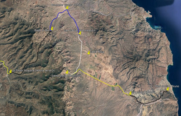
Dec. 14, 1684: Begin from the Real de San Bruno [26.2328, -111.3983] and travel three leagues (6 miles) to San Isidro (San Juan Londó) [26.2262, -111.4729]. Londó was the Native Cochimí name, and the Spaniards called the place San Isidro. A visita of the Loreto mission was established here in 1699 and named San Juan Bautista Londó. A stone block church was built here and is still partially standing just ½ mile west of Highway 1, at Km. 30.
Dec. 15: A little over five leagues (but actually 9.5 miles) to the spring Nebocojol, in a gorge surrounded by very high hills. The Spaniards name it Santa María. The diary book author (Michael Mathes) says Atondo over-estimated his distances, and this spring gorge is probably in Arroyo de San Pedro. Modern maps show that arroyo is too far to the southwest. Santa María (Nebocojol), is most likely at or near today’s Rancho Naocojoa [26.2641, -111.6011], whose name is quite similar to the Native name.
Dec. 16: About five leagues from Santa María to arrive at a stream the Natives call Bunmedojol and renamed (by the Spanish) as San Gabriel. Mathes says this is Rancho Santa Rosa: 26.2997, -111.5572. We believe San Gabriel was further north, 6.5 miles (not 5 leagues) from Santa María, a location called La Luz on modern topo maps [26.3399, -111.5766].
Dec. 17: Traveled four leagues, first to a large stream the Natives called Cupemeyni, and the Spaniards called Santo Tomás. Mathes says this is Arroyo Bombedor, where the expedition turned westward. Rancho Bombedor today is by Highway 1, here: 26.3866, -111.6020 (4 miles from San Gabriel/ Bunmedojol/ La Luz). If Bombedor was their Santo Tomás, indeed the route turns west, and soon southwest, following Arroyo El Tebaye (Teballe) to the base of the mountain. If they camped at the base of the mountain [26.3456, -111.6329], that is four leagues (8 miles) total.
Dec. 18: This next day was used to prepare to cross the mountain by building a trail so that the cargo laden animals could pass. Pry bars, spades, and axes were used by the Admiral, eleven soldiers, and four Christian Indians to build the road.
Dec. 19: Traveled six leagues. There was great difficulty in crossing the mountain, using a pass named Cuesta Trabajosa. Afterward, they turned south. There is a canyon with running water exactly where the diary said they went [26.3318, -111.6478]. After they crossed over the mountain, they went down this drainage [26.3067, -111.6601]. This comes out of the hills by Rancho La Presa, just south of the first Comondú mission. When I measure the distance on satellite imagery, the result is 3 miles to the top of the mountain ridge and 7 more going down to La Presa, 10 miles total. The Natives called this place Comondé, and the Spaniards named it Nuestra Señora de la O [26.2665, -111.7161]. Today’s maps show it as Rancho La Presa, just over ½ mile south of the 1708-1736 San José de Comondú mission ruins. That site was renamed ‘Comondú Viejo’ after the mission moved south to where its town now is. See Comondú Viejo: Nearly A Lost Mission.
From Comondé (Rancho La Presa) the expedition follows this arroyo (here called Arroyo Comondú Viejo and later, Arroyo La Purísima) all the way to the Pacific Ocean.
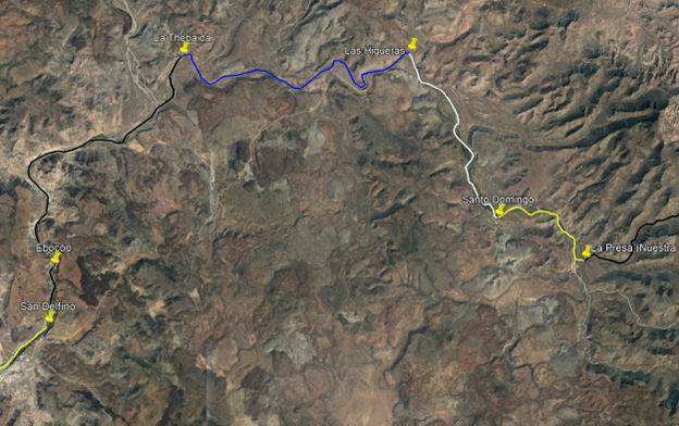
Dec. 20: The party traveled just two leagues (4 miles) down the wide arroyo to Santo Domingo de Silos. I estimate this was where the arroyo turns north [26.2879, -111.7628]. The short distance was due to difficulties with deep water, trees, and boulders, plus some of the animals needing shoes replaced.
Dec. 21: The party traveled north some four leagues (closer to 8 miles) to Las Higueras, where the arroyo turns west [26.3700, -111.8086].
Dec. 22: The party traveled some six leagues (about 10.5 miles) in rocky, difficult, thorny paths that caused many horseshoes to come off. They made camp at a place with a large waterhole (but no pasture) the Natives called Gaelvxu, and the Spaniards named La Thebaida [26.3684, -111.9342]. Map artist Ronald Ives notes this place is 2 miles upstream from Rancho Los Narranjos.
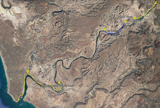
Dec. 23: The expedition followed the riverbed for two leagues and found some springs that formed a river. The day’s traveling ended after going seven leagues at a place the Natives called Ebocoo and the Spanish called Santo Tomás [this is the second place they named Santo Tomás]. Ives says Ebocoo was between Rancho Segundo Paso and Huerta Vieja, or 10 miles of travel. Tracking on satellite maps puts it just south of Huerta Vieja, 11.5 miles of travel [26.2641, -112.0016]. A scouting party explored down river one more league or 13.5 miles total that day to a place they named San Delfino de Pamplona, where the river turned west [26.2358, -112.0031].
Dec. 24: Atondo writes that they left San Delfino de Pamplona and only traveled two leagues (3.5 miles) due to difficulties with boulders and deep pools, causing five horses and their riders to fall and nearly drown. That night they named their camp, Noche Buena (it was Christmas Eve). This camp was set upon a small flatland [26.2068, -112.0477]. Easily seen on a satellite map, it is just east of El Pilón, the dynamic butte in the La Purísima River valley and across from today’s San Isidro.
Dec. 25: A day of rest and Night 2 at Noche Buena
Dec. 26: Noche Buena to San Esteban, five leagues [Atondo says the river here turns southwest]. Ives says this is by El Pilón because of the name they gave it, (looking like a hat). However, that puts it only one league from Noche Buena, not five. This is very near La Purísima, today.
Dec. 27: A day of rest and Night 2 at San Esteban [26.2006, -112.0673]
Dec. 28: San Esteban to Los Inocentes, five leagues [but actually works out closer to two leagues, 26.1856, -112.1115].
Dec. 29: Los Inocentes to Santo Tomás de Cantuaria, seven leagues. This is the third time that Santo Tomás was used as a place name on this trip. [26.0867, -112.2054]
Dec. 30: Santo Tomás to Río Santiago (Arroyo San Gregorio) [26.1064, -112.2698], three leagues plus two more to the sea (10 miles total) along the north side of the river. The location today is called Boca de San Gregorio. One goal was met!
Dec. 31: The Admiral and Padre Kino wished to explore as far north along the beach as possible. They then returned to Río Santiago, traveling sixteen leagues this day (see the Ronald Ives map).
January 1, 1685: They examined the river here as a potential sea harbor and named it Año Nuevo (New Year) before making camp back at Santo Tomás de Cantuaria. The following day begins the return trip to San Bruno. The diary was brief as they used the same route:
Jan. 2: Santo Tomás to Los Inocentes.
Jan. 3: Los Inocentes to an unnamed place, four leagues up-river.
Jan. 4: Up the riverbed for an unspecified distance.
Jan. 5: About three leagues of travel.
Jan. 6: A day of rest.
Jan. 7: Today they traveled to the place they previously had named Las Higueras.
Jan. 8: Las Higueras to Santo Domingo de Silos.
Jan. 9: Santo Domingo to Nuestra Señora de la O (Rancho La Presa).
Jan. 10: A day of rest for most, but Padre Kino and seven soldiers explored the region.
Jan. 11: Nuestra Señora de la O to Santo Tomás (Arroyo Bombedor).
Jan. 12: Santo Tomás south to San Isidro (Londó).
Jan. 13: San Isidro to San Bruno.
Travel Summary:
San Bruno to the Pacific Ocean was fourteen days of travel, one for road building, and two for rest. Admiral Atondo estimated the distance at 70 leagues (~140 miles). When measured today, the distance appears to be closer to 54 leagues (~108 miles). The return trip took eleven days of travel and two days of rest.
The Ronald L. Ives Map from 1960:
The David Kier & H. Pietschmann Estimated Route Map: