 |
By David Kier
Baja California is a land of adventure and with a potential for enjoyment of so many outdoor activities. Surfing is one of those activities and is usually the first thing most travelers think of when Baja's central coast is mentioned. However, surfing along this coast is very limited to such things as the direction of the swell and the weather, leaving most of the year available for different types of fun. The region remains wide open to exploring and enjoying for anyone if they have the appropriate vehicle, such as a four-wheel-drive with extra fuel capacity. There is much to see and do along the central coast of Baja including fishing, beach combing, desert road driving, fossil and mineral hunting, desolate camping, and photography.
The following guide to this region was researched in June 2017 and was previously researched in 2007. In most cases, the ten-year separation showed almost no change in the area and if anything, it is today more deserted and less visited than before. On occasion, the Baja 1000 passes through this region as it had since 1975, the first time this remote Pacific area was visited by this fast-passed event. Other than trucks going to or from a few active fish camps, these roads get little regular traffic. Travel with others if possible or be prepared for any contingent that may arise so far from civilization. A satellite location or communication device is a great idea to keep your friends and family current on your situation.
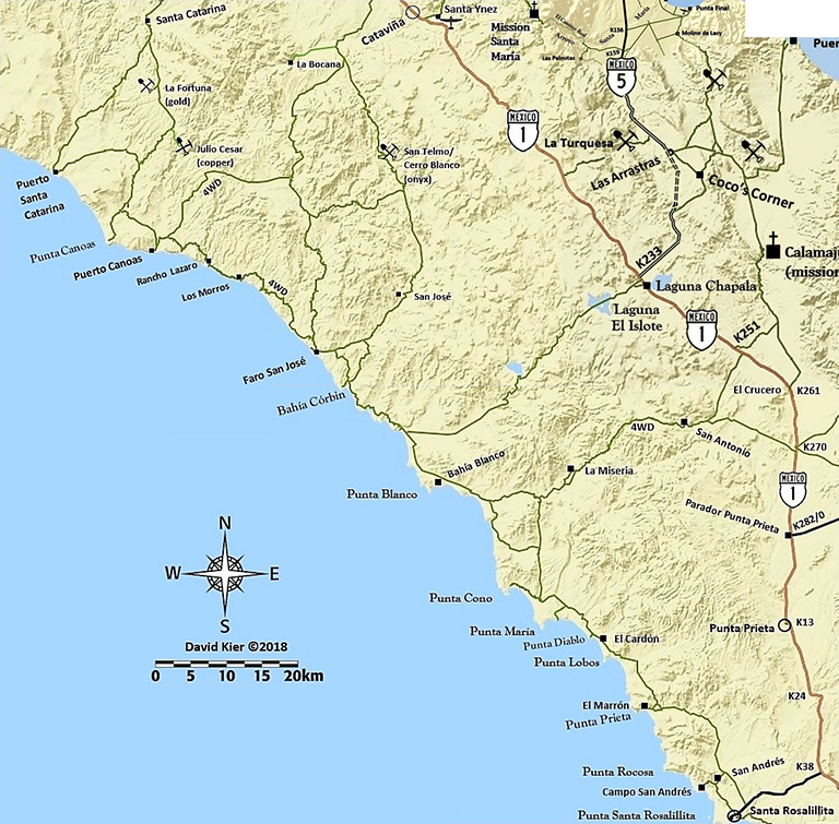
The last outpost southbound for this adventure is El Rosario (Km. 57) where you need to top your fuel tanks at the Baja Cactus Pemex station. The motel next door offers some of the best overnight accommodations along Highway 1 and a new fire station and the area’s rescue service is financed in part by utilizing Baja Cactus Motel and Pemex. A new restaurant is under construction at Baja Cactus, as well. The emergency rescue service covers the needs of accident victims for over 100 miles from El Rosario. See more on their Facebook page.
Last minute supplies and a hot meal can be obtained at any of several places in El Rosario. The kilometer markers along the highway allow for easy navigating to side roads. It is 75 kilometers (46.5 miles) to the dirt road section. Once you are off the highway, the odometer will be utilized to spot road junctions mentioned.
0.0 Highway 1, Km. 132+. Signed road right to Santa Catarina. Set your odometer to zero. It is recommended by off road professionals to lower the air pressure in your tires at least 25% to resist sharp rock punctures and make for a smoother ride. Always have a tire pump to air back up for highway driving.
18.4 Santa Catarina. A tiny ranching community.
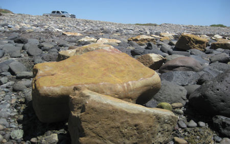
20.3 Fork. Puerto Santa Catarina is to the right and Puerto Canoas is to the left. Going right, the road soon follows the top of a ridge with grand views of the surrounding country and the Pacific Ocean before dropping steeply to the coastal plain. About where it meets the plain, fossilized giant sea snails, known as ammonites, have been found in great numbers. 16.7 miles from the fork is the fish camp of Puerto Santa Catalina. Onyx from El Mármol was shipped to San Diego from here for many years before roads made trucking the attractive stone a more reliable method of transport. Many blocks of onyx are still in the tidal zone here. A road goes from the fish camp south to meet the Puerto Canoas road in 10 miles. Guide continues on the left fork.
24.7 Mina La Fortuna. A gold mine with an entrance gate on the right.
33.9 Road to the right, goes 10 miles to Puerto Santa Catarina.
38.7 Main road curves left. Road ahead ends on a mesa above Punta Canoas.
43.9 Junction with the road that continues south, in from the left. Ahead is Puerto Canoas, 0.5 mile. Here is a small fishing village. No services advertised.
44.7 Crossroad. Turn right, south. Ahead is a windmill. Sign posted here for Lazaro and Los Morros.
45.4 Fork. Keep right. Left fork is now a little used inland road.
50.6 Rancho Lazaro.
54.9 Los Morros.. A home with a white picket fence. The next several miles have many steep grades and washouts. Four-wheel-drive vehicles with good tires are recommended.
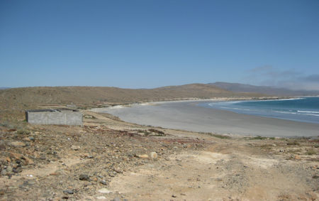
68.0 Junction.Come to the graded road connecting Highway 1 (Km. 168, near Cataviña) with the Faro San José fish camp. Turn right. In a mile go left over a small rise into the camp.
69.1 San José fish camp.No services advertised. A wide beach and an offshore little island. To continue south, reset odometer to zero and take the road that goes along the north side of the lagoon in the valley.
0.0 San José fish camp.
1.8 Fork, go right.
5.6 Fork, go left. Road to the right goes to Bahía Córbin 0.8 mile, and a sand dune-lined bay.
13.8 Junction with a road to Laguna Chapala on Hwy. 1, at Km. 235.
15.5 Junction, turn right. The road soon comes to a salt flat and is the route when dry. Follow the inland track when wet.
20.8 Road right to Bahía Blanco, a fish camp, 0.2 mi. The road on south crosses a salt flat.
25.4 Take road to the right to follow the coast route. The road straight ahead is the inland route and passes La Miseria and climbs a long grade to San Antonio and on to Highway 1 at Km. 252 or 270.5. 4WD only.
33.9 Junction with the inland road, turn right.
38.9 Junction with road to Punta Cono, 3.6 miles. From here on south the road is well-graded and passable to most vehicles for 31 miles to Santa Rosalillita.
42.1 Junction with road to Punta María, 2.5 miles.
46.0 El Cardón camping beach, 0.3 mile. Also known as Punta Diablo, on some maps.
47.0 Rancho El Cardón, on the east side of the road.
49.8 Road right to Punta Lobos and sand dunes.
56.4 Road right to El Marrón fish camp, 1.7 miles.
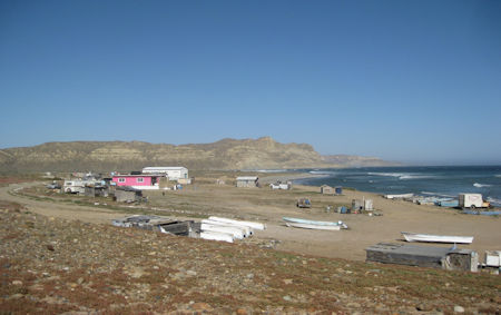
66.1 Road right to Rancho San Andrés (0.9 mile) and on to Campo San Andrés, 2.9 miles.
69.9 Paved road junction. Santa Rosalillita is 0.9 mile to the right and Highway 1 is 7.8 miles to the left, at Km. 38.5.
These 140 miles are a modern example of what travel to Cabo San Lucas was like before 1973 which had even longer sections of non-graded, primitive road. Allow at least two days for the driving time from El Rosario.
About David
David Kier is a veteran Baja traveler, author of 'Baja California - Land Of Missions' and co-author of 'The Old Missions of Baja and Alta California 1697-1834'. Visit the Old Missions website.

Easy to use. been using for over 10 years!

Anytime we cross the border, I go to BAJA BOUND and purchased insurance online. It’s easy and the...

The best. So easy to deal with this company. English speaking also.