 |
By David Kier
Most Baja travelers are probably familiar with the beautiful Bay of San Luis Gonzaga, about 90 miles south from San Felipe. What may be less known is the 1737 Spanish mission of San Luis Gonzaga, 80 miles northwest from La Paz. While Gonzaga Bay can now be reached by paved highway, the old stone mission on the Magdalena Plain of Baja California Sur requires dirt road driving. The graded dirt road from Highway 1 to Mission San Luis Gonzaga was very good and an easy drive when traveled in August 2017. However, the road beyond the mission becomes more interesting! Direction signs are rare, so a good map, GPS device, and a sense of direction will be of great importance.
My game plan was to follow the most traveled roads in the direction intended. Maps often do not show recent changes and detours from recent years of heavy rain. My goal was to see all three of the mission sites of the region; San Luis Gonzaga, La Pasión, and Los Dolores. I also wanted to continue to the gulf coast at San Evaristo and finish at La Paz. The Auto Club map correctly locates the mission locations. The Baja Almanac misplaces La Pasión. The mission ruins are at Rancho La Capilla, about 2 miles northeast of La Presa.
The mission dirt road begins 8 miles south of Ciudad Constitución, on Highway 1, at Km. 195. The road is well-graded but very dusty! Be cautious with speed as there are a few concrete dips along the way that could launch you if you are driving like Robby Gordon. In just over 12 miles is a fork in the road and you will turn right. The road straight ahead goes to a dam and reservoir called Presa El Ihuagil.
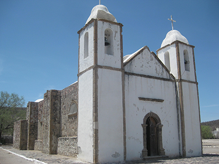
Mission San Luis Gonzaga is 22.3 miles from Highway 1 and is most impressive given the location and age. The church was built from 1753 to 1758. The old and deserted buildings beyond the mission church were from the Mexican ranching and farming years that followed the mission period. A village with about 40 people are all that remain today. Directly north from the mission entrance is an impressive dam and pond, surrounded by palms. Behind the mission is a small graveyard. The location makes an excellent stop on this desert drive. Set your odometer to 0 at the mission.
Going south from San Luis Gonzaga, the road passes several ranches and tiny villages. 8.1 miles from the mission is a fork where a left turn was made. Another left fork is at Mile 10.2 to go in the direction I intended. Looking at the map, the right fork can be used, but it is a longer road going south of Arroyo La Presa.
15.5 miles from San Luis Gonzaga is a T junction and a sign pointing right for Rancho Merecuaco (0.4 mile). Turn left. The road is now seemingly going the wrong way as it climbs between hills, one resembling a turtle. Perhaps that was only my interpretation after miles of bouncing? The road soon circles back towards the south, passes some ranch houses and a weather monitor box then crosses Arroyo La Presa, 20 miles from San Luis Gonzaga. A ranch with a steel water tank is driven by and then a well-graded road is reached at Mile 21.6. Highway 1 is 30 miles to the right at Km. 127. Turn left to continue this adventure.
The entrance to Rancho La Presa is at Mile 26.8. This old ranch has an impressive, mission-looking, modern church, and an oasis. It was a guest ranch for a short time, under the name Misión Dolores, with a website. The gate was locked-closed last August, and the website is no longer online. Continue to Mile 27.3 (from San Luis Gonzaga) and arrive at a junction of roads.
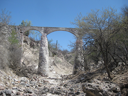
Straight ahead (south) is the route on to La Soledad, San Evaristo, and La Paz. A left turn is made here to visit the site of La Pasión and Los Dolores as well as an interesting aqueduct just east of here. Set odometer to 0.
At Mile 1.3, a road comes in from the left. On the return trip out, I took it just over a half mile to the edge of the arroyo and hiked across the arroyo to see the aqueduct structure built in 1936. GPS: N24°52.940’, W111°02.820’.
At Mile 1.9 is a ranch next to the road and a road to the right that crosses the arroyo. On the south side of the arroyo is La Capilla, a goat ranch on the site of La Pasión.
La Pasión was a visita (visiting station) of Mission Los Dolores. In 1741, the Dolores mission moved from the canyon near the gulf, where it had been since 1721, to La Pasión. This was to better serve the Guaycura Indians who could not come as easily the deep-canyon mission. After the move, the mission was typically called La Pasión rather than its true name, Dolores. The mission was closed by the Spanish government in 1768 and its neophytes were forcibly transferred to Todos Santos.
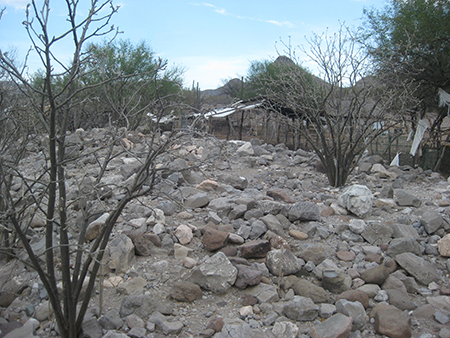
Behind the La Capilla ranch house, next to some goat pens, are the fallen walls of the mission church as well as many stone foundation footing lines. The gate was closed at the front of his ranch, so I drove on the track that went around to the back and parked. The young rancher here, named Modes Amador, welcomed me to see the site and take photos when he came out of his home. GPS: N24°53.250’, W111°01.860’.
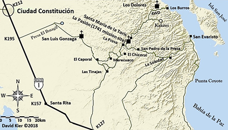
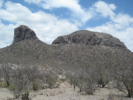
Continuing to the Dolores Mission viewpoint; a village called Santa María de la Toris, with schools for area ranch children, is at Mile 2.8. A fork is reached at Mile 13.3 where the better-looking road goes right heading to the seasonal lake called Llanos de Kakiwi. Take the left fork, with a sign for Los Burros (on the Sea of Cortez coast). The road from here is best traveled in a 4WD, high clearance vehicle. At Mile 17.0, you have reached the peninsular divide at an elevation of 1,520’. The road begins a rough descent. The El Camino Real to Mission Dolores soon branches off the road to the left and is used by modern hikers to reach the mission, far below. At Mile 19.0, a road goes left and is a place to park and hike across a gully and on to the canyon edge to look down and across to the north side and see the walls of Mission Dolores. Bring binoculars! They are at the base of a pyramid-shaped hill. GPS at the ruins: N25°03.330’, W110°53.070’.
The road ahead passes another viewing point in 0.6 mile and continues to the coast at Los Burros. No road goes into the canyon containing the mission. Visitors must hike in on the mission trail or up from a boat landing on the beach, 2.5 miles away.
Baja travel adventures await you down that dusty road. Where it goes never ceases to amaze me.
About David
David Kier is a veteran Baja traveler, author of 'Baja California - Land Of Missions' and co-author of 'The Old Missions of Baja and Alta California 1697-1834'. Visit the Old Missions website.

Super-easy and instant. Very happy with initial purchase.

Baja Bound Insurance has been my go-to for Mexico insurance for years. The website is super easy to...